| ← Back stroke | Next swim → |
Josephine FallsBartle Frere, Far North Queensland
| World Home Page |
| - Australia |
| - Queensland |
| Regions of Queensland: |
| - Far North QLD |
| - South East QLD |
| Other information: |
| Water Safety |
| Map |
| List of Lists |
| Order the book |
| Your Support |
What is it like at one of Australia's best natural rock slides when the emergency flood warning beacon starts flashing? Visiting Josephine falls was a good news / bad news
experience for me. Bad news as a swimmer, but as a hydrologist there was still a silver lining on those heavy storm clouds that had gathered overhead.
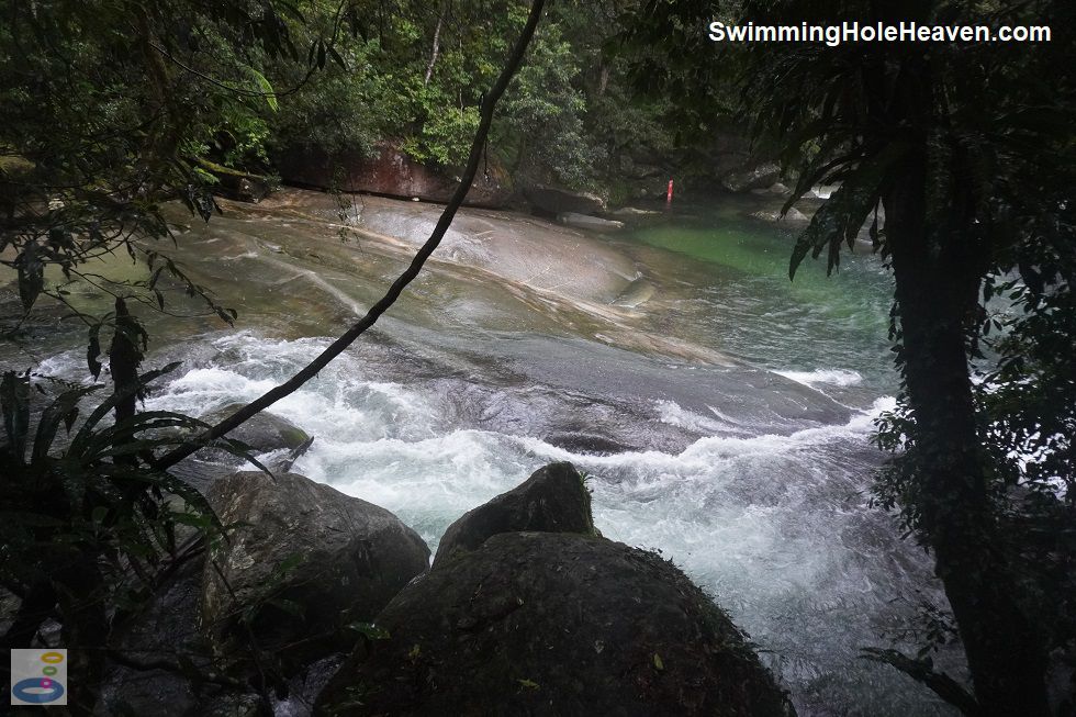
 Above: The smooth sloping rock slide at the bottom pool
(Order this image)
I had been looking forward to visiting Josephine Falls for many years. It's claim to fame is its natural rock slide, which is a few metres high, running across the full width of the river, with a sizeable pool to plunge into below.
Ordinarily, to access the slide, go through the gate at the bottom pool, cross over through the water to the opposite bank. Clamber up the rock face, very carefully wander out along the top lip
of the slide, then sit yourself down and push off. If you have not been here before, watch what other people are doing before you get involved. As with any rock slide, there are risks of scratches
and bumps, including the possibility of knocking your head, so join in at your own risk. This spot is so nice that you can still enjoy a swim here in the bottom pool, even if you do not want to use the slide.
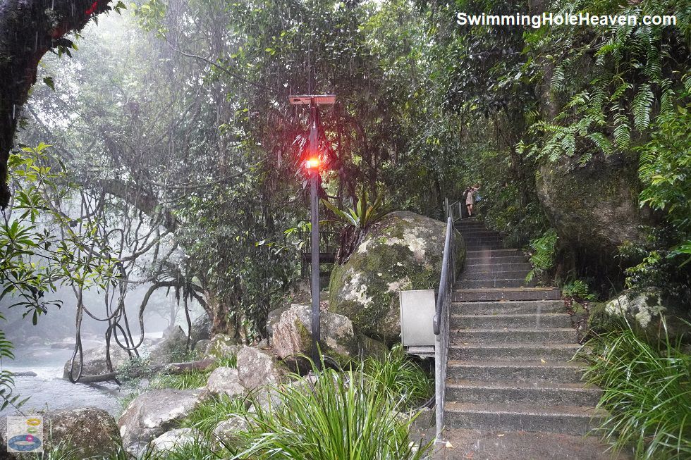
 Above: The flood warning system for swimmers in action
(Order this image)
The gods had however a different idea in mind on my visit. The heavens opened up to such an extent that I was saturated to the core. Out in the open this would be expected, but I was actually underneath an umbrella the whole time and still got soaked through. All the time I was exploring the little paths that lead to different viewing platforms, there was this annoying flashing red light in the trees.
Turns out it was the flood warning system at Josephine Falls, which goes off whenever the creek rises to levels that are unsafe for swimmers. At the access point to the water, the signage was
pretty clear that swimming was not permitted whilst the light was flashing. Whilst I think managing authorities are overly risk averse, in this case, I think they got it right as I watched the
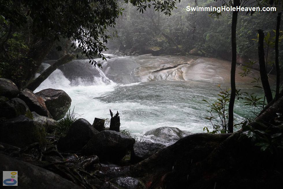
river swell up pretty quickly.
 Above: The rock slide and the bottom pool in flood
(Order this image)
If you are coming here for a picnic, note that the small picnic area is next to the car park, not at the falls, with a 700 metre walk in between.
View Larger Map
Are there crocodiles at Josephine Falls? I have not seen any reports of crocodiles here and there were no warning signs on site.
Can kids swim at Josephine Falls? Yes, under supervision and as long as water levels remain below the high risk zone indicated on site.
Can I have a picnic at Josephine Falls? Yes, but the picnic area is at the car park, 700 metres away from the falls.
Can I fish at Josephine Falls? No, it is within a national park, so no fishing is permitted.
If you have any other questions not answered above, leave a comment for me using the comment box below.
 Above: The smooth sloping rock slide at the bottom pool
(Order this image)
I had been looking forward to visiting Josephine Falls for many years. It's claim to fame is its natural rock slide, which is a few metres high, running across the full width of the river, with a sizeable pool to plunge into below.
 Above: The flood warning system for swimmers in action
(Order this image)
The gods had however a different idea in mind on my visit. The heavens opened up to such an extent that I was saturated to the core. Out in the open this would be expected, but I was actually underneath an umbrella the whole time and still got soaked through. All the time I was exploring the little paths that lead to different viewing platforms, there was this annoying flashing red light in the trees.
 Above: The rock slide and the bottom pool in flood
(Order this image)
If you are coming here for a picnic, note that the small picnic area is next to the car park, not at the falls, with a 700 metre walk in between.
Other Information Before You Go:
Location:Josephine Falls, Wooroonooran National Park, Josephine Falls Road, Bartle Frere, 28 km (approx. 25 minute drive) north-west of Innisfail.
Latitude:-17.438110 Longitude:145.859240
Getting there: From Innisfail, head north along the Bruce Hwy (A1) for approximately 20 km, then head inland at Bartle Frere Road. At Bartle Frere, head west along Price Road / Biggs Road to Josephine Falls Road and follow it to the car park at the end. The route was well signposted from the highway to the falls.
Facilities: Car park, emergency telephone, information boards, public toilets, sheltered public bbqs, sheltered picnic tables, viewing platforms, flood warning system.
Entrance fee: None
Water temperature: Mild
Water clarity: Clear
Under foot: Rock
Maximum water depth: Uncertain, as I did not get to go into the water
Minimum swimming proficiency required: The managing authority advises on site that the falls are not suitable for inexperienced swimmers when the depth indicators are in the high risk zone. At other times, inexperienced swimmers can enter the water in the shallows.
Prohibitions including whether you can bring your dog: No camping, no dogs, no domestic animals, no bicycles, no glass containers, no feeding wildlife, no littering, no disturbing native plants and animals, no smoking within ten metres of public facilities such as toilets, picnic tables, and viewing platforms. Access to the water at the falls and the top pool is prohibited.
Sun shade: Shade available in and out of the water.
Opening times: Always open
Wheelchair access: Wheelchair accessible toilets, wheelchair accessible paths. Some of the viewing platforms are wheelchair accessible, but access to the water for swimming is via steps.
Managing authority: Queensland Department of Environment and Science
Nearby attractions: Golden Hole, a former swimming hole, 2 km by road to the south-west.
Before you head out, make sure to read the
swimming safety information and check with the managing authority for any current change of conditions. Specific to this site, the managing authority
advises that there are slippery rocks, submerged objects, and unpredictable water conditions. People have been seriously injured and died here. During and after heavy rain, creek
conditions can change and become dangerous. Water levels rise rapidly without warning, creating swift currents and making swimming unsafe. The managing authority also advises to
not jump or dive into the creek, and to supervise children at all times.
Latitude:-17.438110 Longitude:145.859240
Getting there: From Innisfail, head north along the Bruce Hwy (A1) for approximately 20 km, then head inland at Bartle Frere Road. At Bartle Frere, head west along Price Road / Biggs Road to Josephine Falls Road and follow it to the car park at the end. The route was well signposted from the highway to the falls.
Facilities: Car park, emergency telephone, information boards, public toilets, sheltered public bbqs, sheltered picnic tables, viewing platforms, flood warning system.
Entrance fee: None
Water temperature: Mild
Water clarity: Clear
Under foot: Rock
Maximum water depth: Uncertain, as I did not get to go into the water
Minimum swimming proficiency required: The managing authority advises on site that the falls are not suitable for inexperienced swimmers when the depth indicators are in the high risk zone. At other times, inexperienced swimmers can enter the water in the shallows.
Prohibitions including whether you can bring your dog: No camping, no dogs, no domestic animals, no bicycles, no glass containers, no feeding wildlife, no littering, no disturbing native plants and animals, no smoking within ten metres of public facilities such as toilets, picnic tables, and viewing platforms. Access to the water at the falls and the top pool is prohibited.
Sun shade: Shade available in and out of the water.
Opening times: Always open
Wheelchair access: Wheelchair accessible toilets, wheelchair accessible paths. Some of the viewing platforms are wheelchair accessible, but access to the water for swimming is via steps.
Managing authority: Queensland Department of Environment and Science
Nearby attractions: Golden Hole, a former swimming hole, 2 km by road to the south-west.
Locality Map:
The marker indicates the approximate location of the parking area. If the map is not zoomed in locally,
as can sometimes occur when loading, simply click or tap on "View Larger Map" below.
View Larger Map
Frequently Asked Questions:
Can my dog swim at Josephine Falls? No, dogs are not permitted to swim here.
Are there crocodiles at Josephine Falls? I have not seen any reports of crocodiles here and there were no warning signs on site.
Can kids swim at Josephine Falls? Yes, under supervision and as long as water levels remain below the high risk zone indicated on site.
Can I have a picnic at Josephine Falls? Yes, but the picnic area is at the car park, 700 metres away from the falls.
Can I fish at Josephine Falls? No, it is within a national park, so no fishing is permitted.
If you have any other questions not answered above, leave a comment for me using the comment box below.
Comments:
If you would like to leave a comment about this swimming spot, please fill in the comment box below.
I am particularly interested in your experiences after visiting, and any changes in conditions, etc.
All fields are required if you would like to see your comments appear on this website.
| ← Back stroke | Next swim → |
| Queensland | FNQ |
| Water Safety | Map |
| Links | Your Support |
| List of Lists | Suggest a Swim |
| Community, Media, Research | |
|
|
|
|
|
|
|
|
|
|
© Brad Neal 2024. All rights reserved. Swimming Hole Heaven is a registered trademark. Here are my
affiliate links and cookies policy and opportunities to provide support to Swimming Hole Heaven.