| ← Back stroke | Next swim → |
Bridgewater Bay, BlairgowrieSwimming Hole Heaven in Melbourne
| World Home Page |
| Australia Home |
| VIC Home |
| Regions of Victoria: |
| Melbourne |
| North East Victoria |
| Gippsland |
| Western Victoria |
| Other information: |
| Water Safety |
| Map |
| List of Lists |
| Order the Book |
| Your Support |
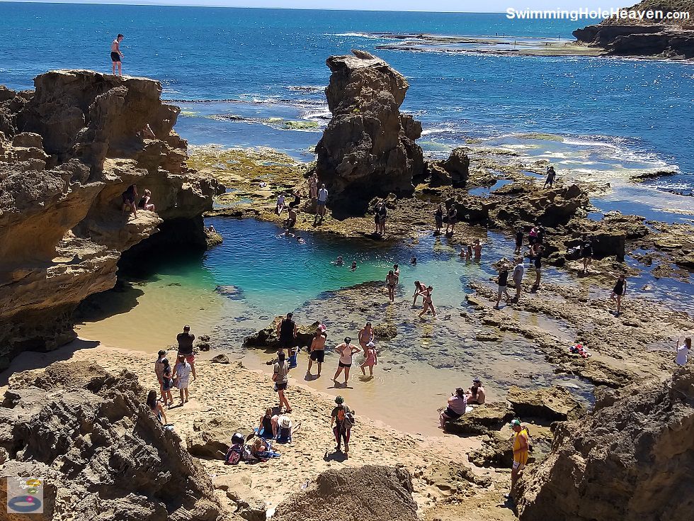
This deep rock pool behind Blairgowrie on the Mornington Peninsula has 3, 6 and 8 metre cliff jumps when accessible at low tide, plus snorkelling around the rim
of the pool. The pool, at the eastern end of Bridgewater Bay, is submerged and inaccessible at high tide.
 Above: Cliff jumping at Bridgewater Bay
(Order this image)
On warm weekends teenagers scramble up the back of the sandstone outcrop that towers above the pool. They line up on the rock ledges like impatient young seabirds, ready to take flight into airs unknown for the first time in their life.
They wait, anxious but eager to drop down into the pool several metres below, as they are urged over the edge by a crowd of on-lookers,
before gravity takes over and there is no turning back. There are also likley to be a few seasoned peacocks doing backflips and tricks.
As with any cliff jumping, do so at your own risk. The pool is up to several metres deep, but it can be much shallower closer to the edge, so check your landing spot well beforehand. Sandstone cliffs can also be crumbly near the edge.
For those swimming and snorkelling, there is thick kelp around the western edge of the pool that clings to a sheer vertical rock wall. It extends downwards deeper than I could see. I spent some time stepping off the sandy bottom to follow a school of juvenile fish that allowed me to swim up fairly close to them.
Visibility is great in between jumps, but disappears
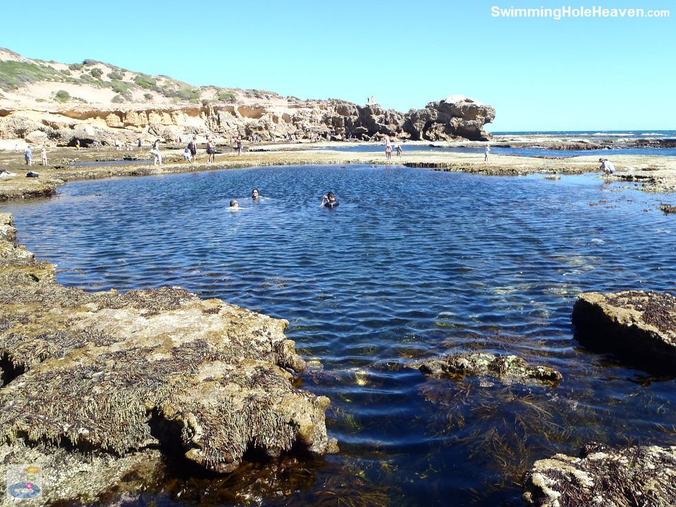
whenever anyone jumps into the water, sending a thick cloud of bubbles out into the pool. For a bubble free swim and snorkel, there is a second, larger rock pool out on the rock shelf that
is also popular for bathing and swimming.
 Above: The larger rock pool at Bridgewater Bay
(Order this image)
This spot is very popular on warm weekends and is only accessible for windows of time at low tide. To avoid the parking chaos at the Bridgewater Bay car park, arrive early on the receding tide or park further away and walk along the bush tracks that run through the dunes along the foreshore.
View Larger Map
If you would like to leave a comment about this swimming hole, please fill in the comment box below. I'm particularly interested in your experiences after visiting, and any changes in swimming conditions. All fields are required if you would like your comments published on this website.
 Above: Cliff jumping at Bridgewater Bay
(Order this image)
On warm weekends teenagers scramble up the back of the sandstone outcrop that towers above the pool. They line up on the rock ledges like impatient young seabirds, ready to take flight into airs unknown for the first time in their life.
As with any cliff jumping, do so at your own risk. The pool is up to several metres deep, but it can be much shallower closer to the edge, so check your landing spot well beforehand. Sandstone cliffs can also be crumbly near the edge.
For those swimming and snorkelling, there is thick kelp around the western edge of the pool that clings to a sheer vertical rock wall. It extends downwards deeper than I could see. I spent some time stepping off the sandy bottom to follow a school of juvenile fish that allowed me to swim up fairly close to them.
 Above: The larger rock pool at Bridgewater Bay
(Order this image)
This spot is very popular on warm weekends and is only accessible for windows of time at low tide. To avoid the parking chaos at the Bridgewater Bay car park, arrive early on the receding tide or park further away and walk along the bush tracks that run through the dunes along the foreshore.
Other Information Before You Go:
Location: Mornington Peninsula National Park, St Johns Wood Road, Blairgowrie, 100 km south of the Melbourne CBD
Latitude:-38.372047 Longitude:144.767060
Getting there: Take the Mornington Peninsula Freeway (M11) to the end then make your way to Blairgowrie via Browns Road / Melbourne Road or the Nepean Hwy. Park at the southern end of St Johns Wood Road, noting the many no standing signs once the small car park is full and the very tight turning circle when you have to turn back.
From the car park it is a 150 metre walk down to the steps to the beach, and a 300 metre walk across the rock shelf at low tide to reach the rock pool.
Facilities: None
Entrance fee: None
Water temperature: Mild
Water clarity: Clear
Under foot: Sand, rock
Maximum water depth: Greater than 2 metres
Minimum swimming proficiency required: Beginners (under supervision, at low tide, noting that the pool gets very deep quickly on the western edge and there is the ever-present threat of being bombarded by cliff jumpers from above). Swimming in the ocean (i.e. outside of the rockpools) and outside of low tide can be dangerous due to the narrow channels that run through the rock shelf that create strong currents.
Prohibitions including whether you can bring your dog: No dogs, no horses, no motorbikes, no bicycles, no camping, no fires
Sun shade: Limited shade available in and out of the water under some of the cliffs
Opening times: Always open, but inaccessible at high tide
Wheelchair access: None
Managing authority: Parks Victoria
Nearby attractions: Peninsula Hot Springs, 10 km to the east
Before you head out, make sure to read the
swimming safety information and check with the managing authority for any current change of conditions. Specific to this site, the managing authority advises that there is no
lifesaving service at this beach and that swimming is dangerous here. The managing authority warns of strong currents, slippery rocks, high surf, submerged rocks and unstable cliffs.
Latitude:-38.372047 Longitude:144.767060
Getting there: Take the Mornington Peninsula Freeway (M11) to the end then make your way to Blairgowrie via Browns Road / Melbourne Road or the Nepean Hwy. Park at the southern end of St Johns Wood Road, noting the many no standing signs once the small car park is full and the very tight turning circle when you have to turn back.
Facilities: None
Entrance fee: None
Water temperature: Mild
Water clarity: Clear
Under foot: Sand, rock
Maximum water depth: Greater than 2 metres
Minimum swimming proficiency required: Beginners (under supervision, at low tide, noting that the pool gets very deep quickly on the western edge and there is the ever-present threat of being bombarded by cliff jumpers from above). Swimming in the ocean (i.e. outside of the rockpools) and outside of low tide can be dangerous due to the narrow channels that run through the rock shelf that create strong currents.
Prohibitions including whether you can bring your dog: No dogs, no horses, no motorbikes, no bicycles, no camping, no fires
Sun shade: Limited shade available in and out of the water under some of the cliffs
Opening times: Always open, but inaccessible at high tide
Wheelchair access: None
Managing authority: Parks Victoria
Nearby attractions: Peninsula Hot Springs, 10 km to the east
Locality Map:
The marker indicates the approximate location of the car park at the start of the walk to Bridgewater Bay. If the map is not zoomed in locally, as can occur with some browsers, simply click or tap on "View Larger Map" below.
View Larger Map
Comments:
If you would like to leave a comment about this swimming hole, please fill in the comment box below. I'm particularly interested in your experiences after visiting, and any changes in swimming conditions. All fields are required if you would like your comments published on this website.
| ← Back stroke | Next swim → |
| Victoria | Melbourne |
| Water Safety | Map |
| List of Lists | Suggest a Swim |
| Links | Your Support |
| Media | Order the Book |
|
|
|
|
|
|
|
|
|
|
© Brad Neal 2024. All rights reserved. Swimming Hole Heaven is a registered trademark. Here are my
affiliate links and cookies policy and opportunities to provide support to Swimming Hole Heaven.