| ← Back stroke | Next swim → |
Lysterfield LakeSwimming Hole Heaven in Melbourne
| World Home Page |
| Australia Home |
| VIC Home |
| Regions of Victoria: |
| Melbourne |
| North East Victoria |
| Gippsland |
| Western Victoria |
| Other information: |
| Water Safety |
| Map |
| List of Lists |
| Order the Book |
| Your Support |
Lysterfield Lake was constructed in the 1930s to supply drinking water to the Mornington Peninsula.
The State Rivers and Water Supply Commission purchased nearby farms in the 1940s and reforested the
lake catchment to protect the quality of its water supply.
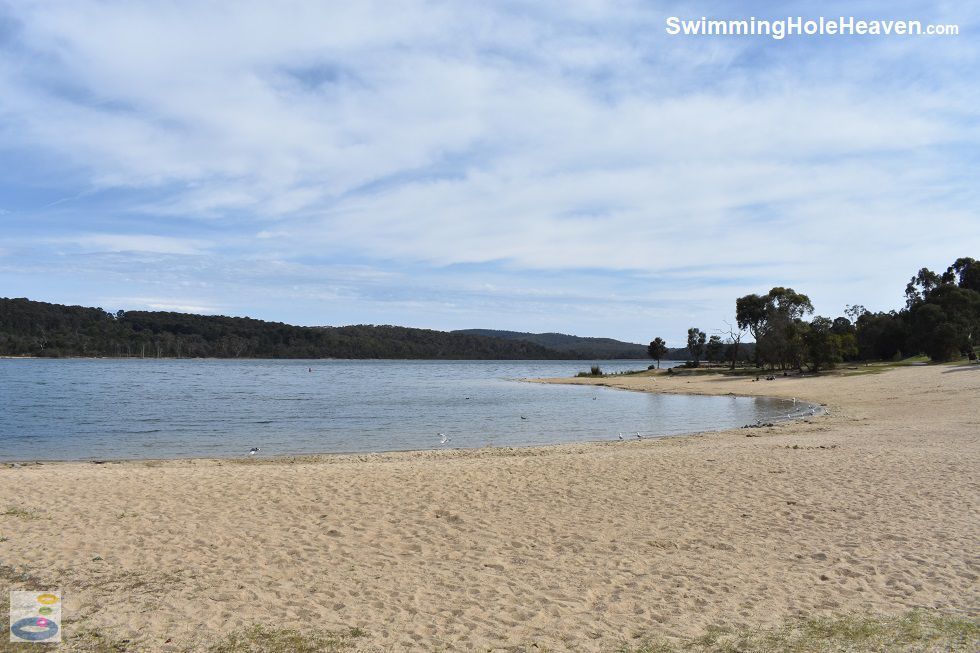
 Above: The main beach at Lysterfield Lake
(Order this image)
This was mostly successful, which is why the quality of water here is generally better than any other rivers and lakes within the Melbourne metropolitan area. However the lake is still plagued by occasional blue-green algae outbreaks. Don't let that put you off - the quality of water in the lake is closely monitored, so you will see warning signs if it is unsafe to swim.
Parks Victoria will also post notification of this on its website. When the quality of water in the lake
is good, as it is most of the time, this is arguably the best natural outdoor swimming venue in Melbourne.
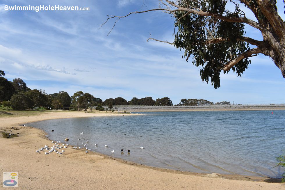
The lake is now managed as a nature reserve with passive recreation. The eastern side of the lake is a recreation area for picnics, bbq's and canoe launching. Two constructed beaches at the south-eastern end of the lake are designated swimming areas. The two curved bays are around 150 m long and the sand stretches back about 15 m from the shore. Above: The second beach at Lysterfield Lake and the dam wall
(Order this image)
The western and northern shores of the lake are inaccessible by foot. A number of well-kept nature trails wind through tea-tree forests inhabited by lively native bird species. The Acacia Nature Walk is a particularly good way to warm up before a swim. Lysterfield Lake Park is ideal for the Sunday family picnic.
The kids can have a swim, a windsurf or go for a bike ride, whilst adults can take a
stroll around the lake before firing up the barbi, having a feed and laying down under a shady tree.
A lot of Melbournians are in on the secret though, so if it is going to be hot, make sure you get there early.
Several people have drowned in separate incidents at Lysterfield Lake. Even though Lysterfield Lake is a relatively safe place to swim, the statistics speak for themselves, so please be careful.
Here is a video that I took when visiting the lake. It was shot on two separate days, one of which was during an algal bloom.
View Larger Map
"Why does [Parks Victoria] not give the up to date water quality readings as is done daily for the swimming beaches? I was told that the water quality is checked regularly so why is that information not made available to the swimming public?" - G. Foster, Melbourne 12/3/2023
My reply: This is a question for Parks Victoria, rather than me. The Victorian State Government has a pretty good setup for reporting raw water quality data, with its Water Measurement Information System, but Lysterfield Lake is not part of that program. You could ask Parks Victoria whether the Lysterfield Lake data could be uploaded to the Water Measurement Information System, so that it is available for the public to access. The EPA's beach report enterecocci data you mentioned is a different approach, providing a simple spreadsheet of historical data samples just for that dataset, which looks like it could also be an option for Parks Victoria. Water quality alerts for swimming at Lysterfield Lake are published by Parks Victoria on its website and its social media.
If you would like to leave a comment about this swimming hole, please fill in the comment box below. I'm particularly interested in your experiences after visiting, and any changes in swimming conditions. All fields are required if you would like your comments published on this website.
 Above: The main beach at Lysterfield Lake
(Order this image)
This was mostly successful, which is why the quality of water here is generally better than any other rivers and lakes within the Melbourne metropolitan area. However the lake is still plagued by occasional blue-green algae outbreaks. Don't let that put you off - the quality of water in the lake is closely monitored, so you will see warning signs if it is unsafe to swim.
The lake is now managed as a nature reserve with passive recreation. The eastern side of the lake is a recreation area for picnics, bbq's and canoe launching. Two constructed beaches at the south-eastern end of the lake are designated swimming areas. The two curved bays are around 150 m long and the sand stretches back about 15 m from the shore.
 Above: The second beach at Lysterfield Lake and the dam wall
(Order this image)
The western and northern shores of the lake are inaccessible by foot. A number of well-kept nature trails wind through tea-tree forests inhabited by lively native bird species. The Acacia Nature Walk is a particularly good way to warm up before a swim. Lysterfield Lake Park is ideal for the Sunday family picnic.
Several people have drowned in separate incidents at Lysterfield Lake. Even though Lysterfield Lake is a relatively safe place to swim, the statistics speak for themselves, so please be careful.
Here is a video that I took when visiting the lake. It was shot on two separate days, one of which was during an algal bloom.
Other Information Before You Go:
Location: Lysterfield, 30 km east of the Melbourne CBD
Latitude:-37.965617 Longitude:145.29792
Getting there: From Melbourne take the Monash Freeway to Wellington Road or Heatherton Road. The entrance is in Horswood Road off the Belgrave-Hallam Road
Facilities: Toilets, bbqs, tables, lawns, parking, public telephone, nature walk, bike paths, cafe
Entrance fee: None
Water temperature, water clarity, conditions under foot in the water, maximum water depth, minimum swimming proficiency required, prohibitions including whether you can bring your dog: Order the full guide
Sun shade: Shade available out of the water
Opening times: Restricted opening times. Order the full guide for more details.
Wheelchair access: Bitumen trail extends through the picnic area and across the dam wall. Toilet facilities for the disabled.
Managing authority: Parks Victoria
Nearby attractions: If Lysterfield Lake is full, head to Cardinia Reservoir Park to see some kangaroos
Before you head out, make sure to read the swimming safety information and check with the managing authority for any current change of conditions.
Latitude:-37.965617 Longitude:145.29792
Getting there: From Melbourne take the Monash Freeway to Wellington Road or Heatherton Road. The entrance is in Horswood Road off the Belgrave-Hallam Road
Facilities: Toilets, bbqs, tables, lawns, parking, public telephone, nature walk, bike paths, cafe
Entrance fee: None
Water temperature, water clarity, conditions under foot in the water, maximum water depth, minimum swimming proficiency required, prohibitions including whether you can bring your dog: Order the full guide
Sun shade: Shade available out of the water
Opening times: Restricted opening times. Order the full guide for more details.
Wheelchair access: Bitumen trail extends through the picnic area and across the dam wall. Toilet facilities for the disabled.
Managing authority: Parks Victoria
Nearby attractions: If Lysterfield Lake is full, head to Cardinia Reservoir Park to see some kangaroos
Locality Map:
The marker indicates the approximate location of the shallower swimming beaches at the lake. If the map is not zoomed in locally, as can occur with some browsers, simply click or tap on "View Larger Map" below.
View Larger Map
Comments:
Here is one query I received about the water quality information at Lysterfield Lake:
"Why does [Parks Victoria] not give the up to date water quality readings as is done daily for the swimming beaches? I was told that the water quality is checked regularly so why is that information not made available to the swimming public?" - G. Foster, Melbourne 12/3/2023
My reply: This is a question for Parks Victoria, rather than me. The Victorian State Government has a pretty good setup for reporting raw water quality data, with its Water Measurement Information System, but Lysterfield Lake is not part of that program. You could ask Parks Victoria whether the Lysterfield Lake data could be uploaded to the Water Measurement Information System, so that it is available for the public to access. The EPA's beach report enterecocci data you mentioned is a different approach, providing a simple spreadsheet of historical data samples just for that dataset, which looks like it could also be an option for Parks Victoria. Water quality alerts for swimming at Lysterfield Lake are published by Parks Victoria on its website and its social media.
If you would like to leave a comment about this swimming hole, please fill in the comment box below. I'm particularly interested in your experiences after visiting, and any changes in swimming conditions. All fields are required if you would like your comments published on this website.
| ← Back stroke | Next swim → |
| Victoria | Melbourne |
| Water Safety | Map |
| List of Lists | Suggest a Swim |
| Links | Your Support |
| Media | Order the Book |
|
|
|
|
|
|
|
|
|
|
© Brad Neal 2024. All rights reserved. Swimming Hole Heaven is a registered trademark. Here are my
affiliate links and cookies policy and opportunities to provide support to Swimming Hole Heaven.