| ← Back stroke | Next splash → |
Wombat Bend Playground, Lower TemplestoweSplash parks in Melbourne, Australia
| World Home Page |
| Australia Home |
| VIC Home |
| Regions of Victoria: |
| Melbourne |
| North East Victoria |
| Gippsland |
| Western Victoria |
| Other information: |
| Water Safety |
| Map |
| List of Lists |
| Order the Book |
| Your Support |
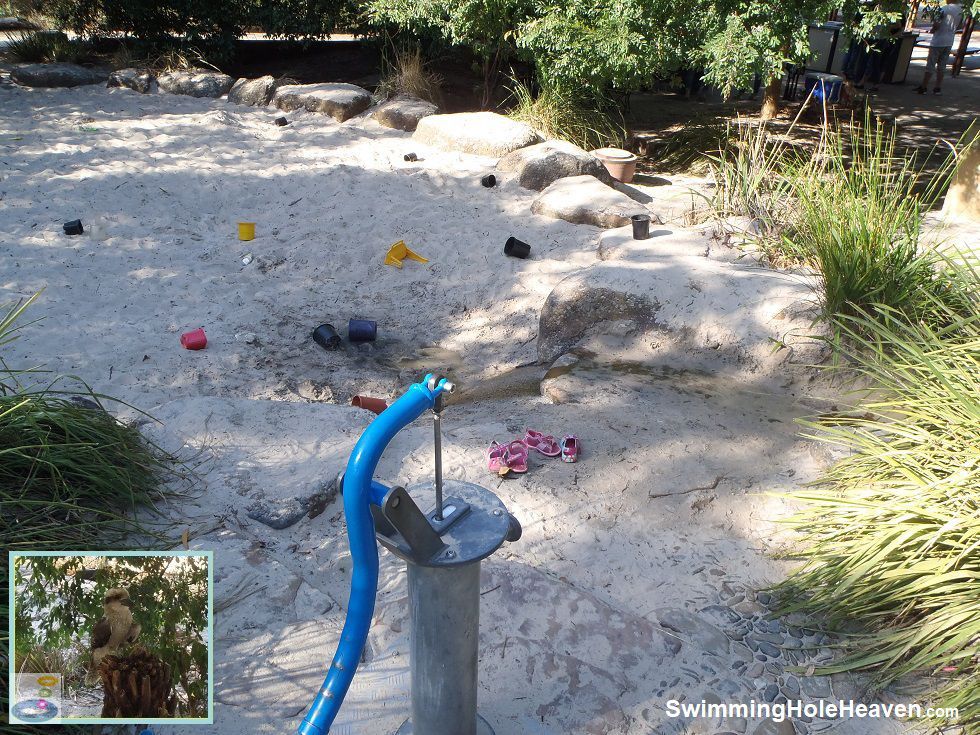
Wombat Bend playground in Lower Templestowe is a fantastic playground with a wide variety of innovative play spaces and equipment, but its water feature, as designed,
performs poorly. The hand pump is permanently locked and the mini-aqueduct is only able to run at a trickle because it is often clogged with sand. However,
I have a solution for all of those determined kids and parents who want to soup-up this water feature and turn it back into the fun water play activity that it
was originally meant to be.
 Above: The trickling stream flowing into the giant sandpit Inset: The kookaburra who keeps watch over the barbecue at close range
(Order this image)
If you press the large silver buttons on the mini-aqueduct, the water only comes out at a trickle. I ended up with a big red circle on my thigh from trying to hold the button in until I came up with a better idea. Next to the barbecue area near the sandpit, there is a tap.
What you need to do is bring
some buckets, ideally 2-3 that you can ferry back and forth. Fill them up and empty them into the top of the aqueduct to create a decent torrent
of water in the aqueduct and the stream it drains into.
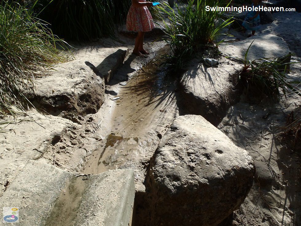
Kids can operate the buckets themselves and follow the pulse of water down the length of the water feature. Alternatively they can wait in anticipation for the water to arrive in the artificial stream at the end of the aqueduct, and then jump in the temporary pool when the water spills down into the sandpit. The buckets of water also flush out the sand so that the buttons work more effectively afterwards. Above: Playing in the sandy stream at the end of the mini-aqueduct
(Order this image)
The playground itself is one of the best that I have come across in Melbourne. It is fully enclosed and has some great features including a maze, the giant sandpit, a sundial, a sea-saw that looks like two park benches on springs, two flying foxes, slides and a batman-esque swing.
The barbecues inside the fenced playground are
extremely popular, so get there early or be very patient if you want to use them on weekends. Keep a lookout for the curious kookaburra, which perches itself
on a tree fern next to the barbecue, waiting completely still for some scraps of meat.
The Yarra River is next door to the playground, but is not really suitable for swimming in due to the poor water quality here most of the time.
View Larger Map
 Above: The trickling stream flowing into the giant sandpit Inset: The kookaburra who keeps watch over the barbecue at close range
(Order this image)
If you press the large silver buttons on the mini-aqueduct, the water only comes out at a trickle. I ended up with a big red circle on my thigh from trying to hold the button in until I came up with a better idea. Next to the barbecue area near the sandpit, there is a tap.
Kids can operate the buckets themselves and follow the pulse of water down the length of the water feature. Alternatively they can wait in anticipation for the water to arrive in the artificial stream at the end of the aqueduct, and then jump in the temporary pool when the water spills down into the sandpit. The buckets of water also flush out the sand so that the buttons work more effectively afterwards.
 Above: Playing in the sandy stream at the end of the mini-aqueduct
(Order this image)
The playground itself is one of the best that I have come across in Melbourne. It is fully enclosed and has some great features including a maze, the giant sandpit, a sundial, a sea-saw that looks like two park benches on springs, two flying foxes, slides and a batman-esque swing.
The Yarra River is next door to the playground, but is not really suitable for swimming in due to the poor water quality here most of the time.
Other Information Before You Go:
Location: Finns Reserve, Duncan St, Lower Templestowe, 18 km (around 30 minute drive)
north-east of the Melbourne CBD
Latitude:-37.753942 Longitude:145.115557
Getting there: By car, from the city take the Eastern Freeway (M3) to the Bulleen/Thompsons Rd exit. Follow Thompsons Rd (highway route 42) to Lower Templestowe, and then continue on to Union Street at the Templestowe Rd/Foote St intersection. Duncan St is 300 metres on the left. Car parking is available at the end of Duncan St. By public transport, take bus 905 from the corner of Swanston St and Lonsdale St in the city and hop off around 30 minutes later at the corner of Foote St and Thompsons Rd. You will then need to walk around 400 metres down Union St and then Duncan St to the playground. You can also ride from the city by bicycle along the Main Yarra Trail. When you get to Lower Templestowe, head across the pedestrian bridge and turn right along the Ruffey Trail, which runs alongside Wombat Bend playground on the southern side of the Yarra River.
General facilities: Toilets, sheltered picnic tables, playground, maze, drinking fountain, rubbish bins, car parking, barbecue facilities, bike racks, amphitheatre.
Baby change facilities: Yes
Sun shade: Partial shade over the water feature and the sandpit at most times of the day.
Entrance fee: None
Opening times: Always open
Wheelchair access: Wheelchair accessible paths, disabled parking, wheelchair accessible toilets.
Prohibitions: No smoking, no bike riding within the playground area, no dogs within the playground area, dogs off leads permitted outside of the playground area
Managing authority: Manningham City Council
Nearby attractions: The Main Yarra Bike Trail
Before you head out, make sure to read the water safety information and check with the managing authority for any current change of conditions.
Latitude:-37.753942 Longitude:145.115557
Getting there: By car, from the city take the Eastern Freeway (M3) to the Bulleen/Thompsons Rd exit. Follow Thompsons Rd (highway route 42) to Lower Templestowe, and then continue on to Union Street at the Templestowe Rd/Foote St intersection. Duncan St is 300 metres on the left. Car parking is available at the end of Duncan St. By public transport, take bus 905 from the corner of Swanston St and Lonsdale St in the city and hop off around 30 minutes later at the corner of Foote St and Thompsons Rd. You will then need to walk around 400 metres down Union St and then Duncan St to the playground. You can also ride from the city by bicycle along the Main Yarra Trail. When you get to Lower Templestowe, head across the pedestrian bridge and turn right along the Ruffey Trail, which runs alongside Wombat Bend playground on the southern side of the Yarra River.
General facilities: Toilets, sheltered picnic tables, playground, maze, drinking fountain, rubbish bins, car parking, barbecue facilities, bike racks, amphitheatre.
Baby change facilities: Yes
Sun shade: Partial shade over the water feature and the sandpit at most times of the day.
Entrance fee: None
Opening times: Always open
Wheelchair access: Wheelchair accessible paths, disabled parking, wheelchair accessible toilets.
Prohibitions: No smoking, no bike riding within the playground area, no dogs within the playground area, dogs off leads permitted outside of the playground area
Managing authority: Manningham City Council
Nearby attractions: The Main Yarra Bike Trail
Locality Map:
The marker indicates the location of the sand pit at the playground. If the map is not zoomed in locally, as can occur with some browsers, simply click or tap on "View Larger Map" below.
View Larger Map
Comments:
If you would like to leave a comment about this shallow water play area, please fill in the comment box below.
I'm particularly interested in your experiences after visiting, and any changes in conditions, etc.
Make sure you let me know whether you consent to having your comments published on this website.
| ← Back stroke | Next splash → |
| Victoria | Melbourne |
| Water Safety | Map |
| List of Lists | Suggest a Swim |
| Links | Your Support |
| Media | Order the Book |
|
|
|
|
|
|
|
|
|
|
© Brad Neal 2024. All rights reserved. Swimming Hole Heaven is a registered trademark. Here are my
affiliate links and cookies policy and opportunities to provide support to Swimming Hole Heaven.