| ← Back stroke | Next swim → |
Young's Creek ReservoirSwimming Hole Heaven in Victoria
| World Home Page |
| Australia Home |
| VIC Home |
| Regions of Victoria: |
| Melbourne |
| North East Victoria |
| Gippsland |
| Western Victoria |
| Other information: |
| Water Safety |
| Map |
| List of Lists |
| Order the Book |
| Your Support |
This century-old, former water supply reservoir offers a no frills, open-water swim in the bush north of Orbost. It is accessible by foot via a
2 km hike from the Young's Creek Picnic Area.
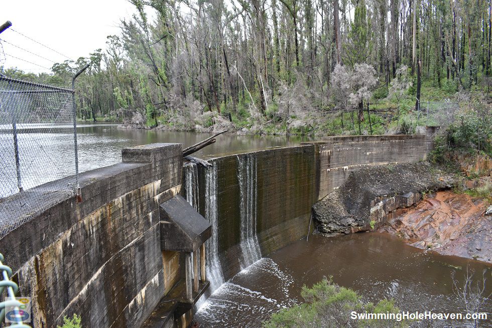
 Above: The dam wall at Young's Creek Reservoir
(Order this image)
The water supply from this reservoir was decommissioned several decades ago due to its poorer drinking water quality, relative to other nearby water sources, and its ageing infrastructure. There is a naturally brown hue to the water that limits visibility under the water to not more than half a metre.
This was exacerbated by the fires that swept through here in 2020, with ash and sediment washed into the reservoir in the months thereafter. When going for a swim, I picked an entry point away from any visible woody debris near the edge, being careful to watch out for submerged branches.
In the upstream half of the reservoir, the water tends
to get too shallow, with underwater hazards that are difficult to see.
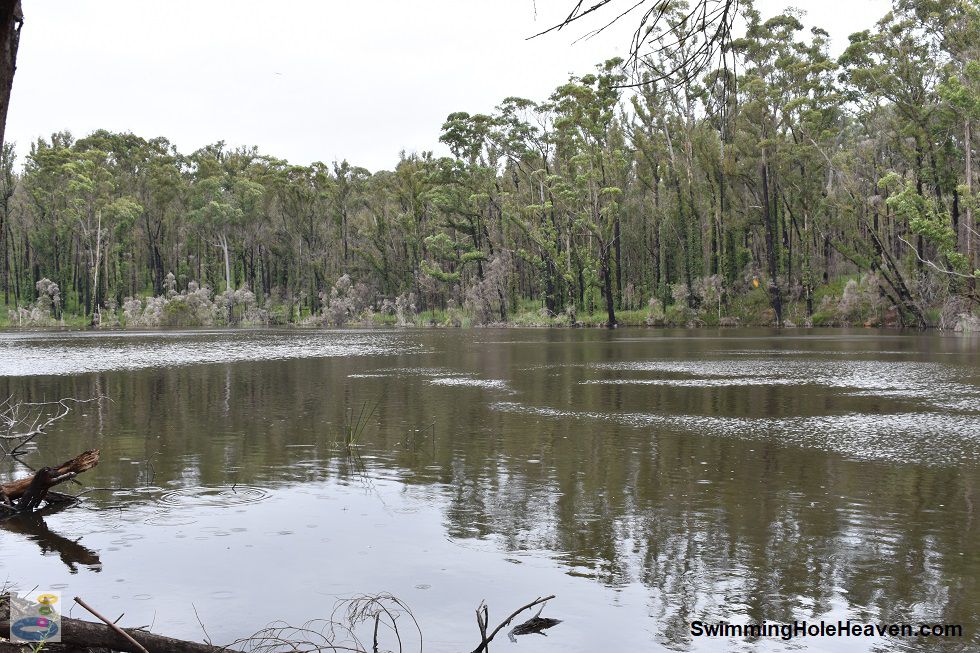
Once away from the edge, the depth increases quickly and I found the reservoir clear for swimming around 150 metre lengths up and down, surrounded by the sights and sounds of the bush in perfect isolation. Out in the middle it was a wonderfully free swim, and will only get better as the forest regrows. Above: Young's Creek Reservoir
(Order this image)
After I found my swimming spot, I did not walk the full length of the reservoir track that runs along the western shore. There were no facilities at the reservoir that I could see, and away from the dam wall, only very limited clear space for my gear.
However there are picnic tables and a pit toilet back at the Young's Creek Picnic Area, before and after your hike and swim here.
Here is a video of my swim in the reservoir, including the dam wall and some track notes on the walk from the picnic ground. It was taken in January when the reservoir was spilling after a reasonably wet December.
View Larger Map
 Above: The dam wall at Young's Creek Reservoir
(Order this image)
The water supply from this reservoir was decommissioned several decades ago due to its poorer drinking water quality, relative to other nearby water sources, and its ageing infrastructure. There is a naturally brown hue to the water that limits visibility under the water to not more than half a metre.
This was exacerbated by the fires that swept through here in 2020, with ash and sediment washed into the reservoir in the months thereafter. When going for a swim, I picked an entry point away from any visible woody debris near the edge, being careful to watch out for submerged branches.
Once away from the edge, the depth increases quickly and I found the reservoir clear for swimming around 150 metre lengths up and down, surrounded by the sights and sounds of the bush in perfect isolation. Out in the middle it was a wonderfully free swim, and will only get better as the forest regrows.
 Above: Young's Creek Reservoir
(Order this image)
After I found my swimming spot, I did not walk the full length of the reservoir track that runs along the western shore. There were no facilities at the reservoir that I could see, and away from the dam wall, only very limited clear space for my gear.
Here is a video of my swim in the reservoir, including the dam wall and some track notes on the walk from the picnic ground. It was taken in January when the reservoir was spilling after a reasonably wet December.
Other Information Before You Go:
Location: Young's Creek Picnic Ground, Storers Track off Bonang Road (C612), 12 km north of Orbost and 380 km (approx. 4.5 hour drive) east of the Melbourne CBD.
Latitude:-37.656251 Longitude:148.514571
Getting there: From Orbost, head north along the Bonang Road (C612) for approximately 5 km, then head east along the Four and a Half Mile Track, which then becomes the Stock Track. This dirt road was suitable for 2WD vehicles in dry conditions during my visits here. At the Storers Track junction, follow the signs to the picnic area by heading south along Storers Track until you reach the Young's Creek Picnic Area. From the picnic area, park your car and walk along the Iron Chimney Track or the Loop Track heading north. If taking the Iron Chimney Track, remember to turn left (which is actually part of the return loop walk) about 80 metres from the start of the walk, just as you start going up the hill. Once on this track, follow the signs to the reservoir, just over 2 km to the north. If you just want to visit the reservoir, there is a slightly shorter route via the Reservoir Track (approximately 1.5 km one way), which starts at the northern end of Storers Track (i.e. head north by car at the Storers Track junction mentioned above), but I have not walked this route.
Facilities: None at the reservoir. At the picnic area there is a toilet, unsheltered picnic tables, car park and wood fire pits. There are no bins, so please take your rubbish home with you.
Entrance fee: None
Water temperature: Mild
Water clarity: Murky
Under foot: Leaf litter on soft clay/mud
Maximum water depth: Greater than 2 metres
Minimum swimming proficiency required: Experienced
Prohibitions including whether you can bring your dog: No camping. Dogs permitted.
Sun shade: Shade available out of the water. Limited to no shade available in the water.
Opening times: Always open
Wheelchair access: None
Managing authority: Victorian Department of Environment, Land, Water and Planning
Nearby attractions: Young's Creek Falls, which are a 400 metre walk south from the picnic area.
Before you head out, make sure to read the
swimming safety information and check with the managing authority for any current change of conditions.
Latitude:-37.656251 Longitude:148.514571
Getting there: From Orbost, head north along the Bonang Road (C612) for approximately 5 km, then head east along the Four and a Half Mile Track, which then becomes the Stock Track. This dirt road was suitable for 2WD vehicles in dry conditions during my visits here. At the Storers Track junction, follow the signs to the picnic area by heading south along Storers Track until you reach the Young's Creek Picnic Area. From the picnic area, park your car and walk along the Iron Chimney Track or the Loop Track heading north. If taking the Iron Chimney Track, remember to turn left (which is actually part of the return loop walk) about 80 metres from the start of the walk, just as you start going up the hill. Once on this track, follow the signs to the reservoir, just over 2 km to the north. If you just want to visit the reservoir, there is a slightly shorter route via the Reservoir Track (approximately 1.5 km one way), which starts at the northern end of Storers Track (i.e. head north by car at the Storers Track junction mentioned above), but I have not walked this route.
Facilities: None at the reservoir. At the picnic area there is a toilet, unsheltered picnic tables, car park and wood fire pits. There are no bins, so please take your rubbish home with you.
Entrance fee: None
Water temperature: Mild
Water clarity: Murky
Under foot: Leaf litter on soft clay/mud
Maximum water depth: Greater than 2 metres
Minimum swimming proficiency required: Experienced
Prohibitions including whether you can bring your dog: No camping. Dogs permitted.
Sun shade: Shade available out of the water. Limited to no shade available in the water.
Opening times: Always open
Wheelchair access: None
Managing authority: Victorian Department of Environment, Land, Water and Planning
Nearby attractions: Young's Creek Falls, which are a 400 metre walk south from the picnic area.
Locality Map:
The marker indicates the approximate location of the start of the walk to the reservoir from Young's Creek Picnic Area. If the map is not zoomed in locally, as can occur with some browsers, simply click or tap on "View Larger Map" below.
View Larger Map
Comments:
If you would like to leave a comment about this swimming spot, please fill in the comment box below. I'm particularly interested in your
experiences after visiting, and any changes in swimming conditions. All fields are required if you would like your comments published on this website.
| ← Back stroke | Next swim → |
| Victoria | Gippsland |
| Water Safety | Map |
| List of Lists | Suggest a Swim |
| Links | Your Support |
| Media | Order the Book |
|
|
|
|
|
|
|
|
|
|
© Brad Neal 2024. All rights reserved. Swimming Hole Heaven is a registered trademark. Here are my
affiliate links and cookies policy and opportunities to provide support to Swimming Hole Heaven.