| ← Back stroke | Next swim → |
Lake Burley Griffin at Black Mountain PeninsulaActon, ACT
| World Home Page |
| Australia Home |
| NSW / ACT Home |
| NSW and ACT Regions: |
| Canberra and ACT |
| South Coast |
| Southern Inland |
| Sydney |
| Other information: |
| Water Safety |
| Map |
| List of Lists |
| Your Support |
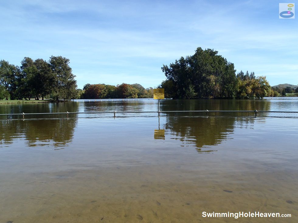
The swimming beach on Black Mountain Peninsula is located on the western side of the peninsula, in a curved bay protected from the main current in
Lake Burley Griffin by the headland and a small island. The island is 40-80 metres offshore, depending on where you start your swim from. It
provides a goal to reach if you're not already encouraged by the better views of Black Mountain from the water, which looms large at one
end of the beach.
 Above: View from the swimming beach at Black Mountain Peninsula in Lake Burley Griffin
(Order this image)
A boundary rope that runs between the island and the peninsula marks the edge of the designated swimming area.
Closer to shore there is a smaller fenced enclosure for kids to play in. It extends about 15 metres out into the water with mostly sand under foot.
The beach itself is a little scrappy with fairly hard sand that has clumped together, and which is gradually being colonised by the buffalo grass spreading out
from the picnic area. If you get there early, there is a solitary gum tree at the back of the beach that provides shade on the sand in the morning.
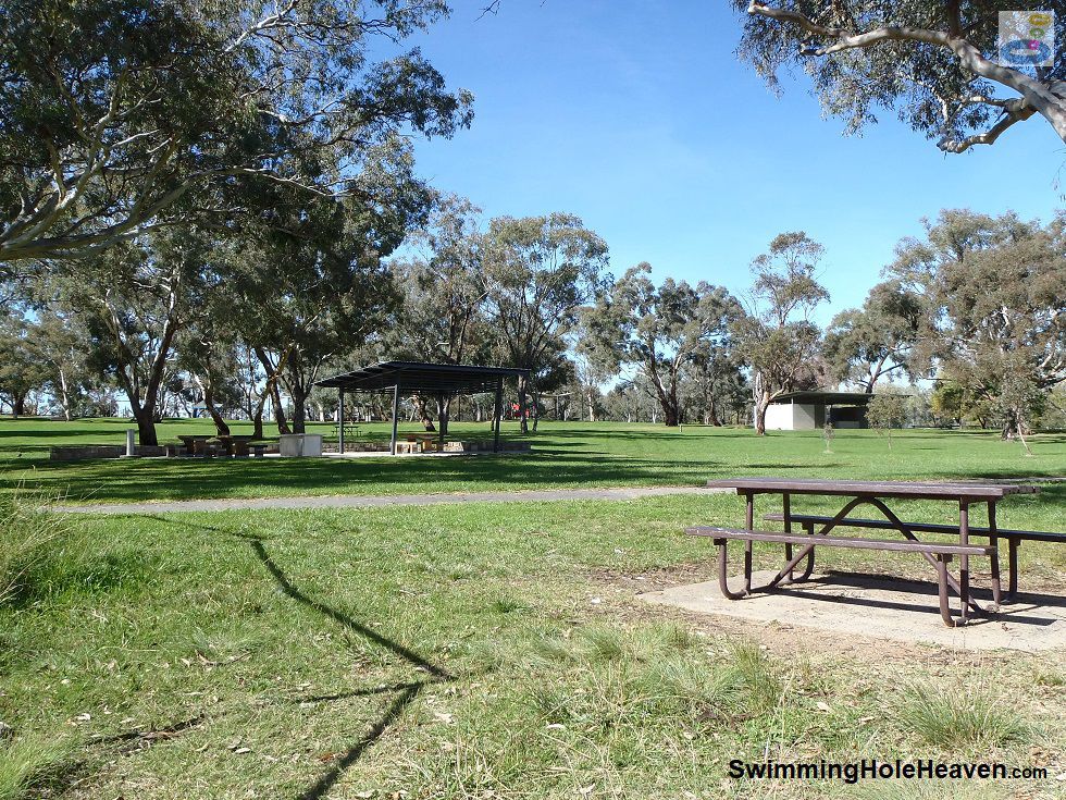
 Above: The barbecue area at the swimming beach on Black Mountain Peninsula
(Order this image)
The picnic facilities behind the beach have recently been upgraded and include covered picnic tables and barbecues, and there's plenty of open space and lawn area. The playground is at the top of the hill and a bit of a walk, but also within reach. For anyone in Canberra Central or Acton, this is probably the closest lake swim available.
Swimming in Lake Burley Griffin is not as enjoyable as some of the swimming spots in the Murrumbidgee River corridor out of town because of the poor visibility in the water.
It has a greeny-brown hue that you don't really want to submerge your head in, but this
area is well monitored for water quality over summer, and the beach will be closed when the water quality is unsuitable for swimming.
View Larger Map
 Above: View from the swimming beach at Black Mountain Peninsula in Lake Burley Griffin
(Order this image)
A boundary rope that runs between the island and the peninsula marks the edge of the designated swimming area.
Closer to shore there is a smaller fenced enclosure for kids to play in. It extends about 15 metres out into the water with mostly sand under foot.
 Above: The barbecue area at the swimming beach on Black Mountain Peninsula
(Order this image)
The picnic facilities behind the beach have recently been upgraded and include covered picnic tables and barbecues, and there's plenty of open space and lawn area. The playground is at the top of the hill and a bit of a walk, but also within reach. For anyone in Canberra Central or Acton, this is probably the closest lake swim available.
Swimming in Lake Burley Griffin is not as enjoyable as some of the swimming spots in the Murrumbidgee River corridor out of town because of the poor visibility in the water.
Other Information Before You Go:
Location: John Cardiff Close, Acton ACT, 5 km (approx. 10 min. drive) west of Canberra Central.
Latitude:-35.291207 Longitude:149.099697
Getting there: From the city head west along Parkes Way and then left onto Lady Denman Drive when you see the signs to Black Mountain Peninsula. As you approach the Peninsula, turn down Garry Owen Drive and follow it down the hill. Turn right down John Cardiff Close, veering to the left branch, for the car park closest to the beach, or follow Garry Owen Drive all the way to the end for the alternative car park nearest the toilets. There are two hour parking limits in some spots.
Facilities: Car park, toilets, powered barbecues, picnic tables (sheltered and unsheltered), drinking fountain, life saving buoy, lawn area, beach, rubbish bins. There are various other facilities throughout the park, further away, including a playground and a rowing club.
Entrance fee: None
Water temperature: Mild
Water clarity: Murky
Under foot: Sand
Maximum water depth: Greater than 2 metres
Suggested minimum swimming proficiency required: Beginners (under supervision)
Prohibitions including whether you can bring your dog: No dogs
Sun shade: Shade available out of the water near some of the picnic facilities, but not on the beach. No shade available in the water.
Opening times: Always open
Wheelchair access: Wheelchair accessible toilet and wheelchair accessible paths to some of the picnic facilities. Grade down to the water is fairly flat across spongy grass and sand.
Managing authority: ACT Government
Nearby attractions: Weston Park swimming beach, which you can see directly opposite the beach at Black Mountain Peninsula, on the other side of the lake.
Before you head out, make sure to read the
swimming safety information and check with the managing authority for any current change of conditions. Water quality in the Canberra area can sometimes
be unsuitable for swimming. For regular updates on whether the water quality at this site is suitable for swimming,
see the website/app used by the ACT Government to notify swimmers of
water quality alerts. Signs on site indicate when the lake is closed for swimming due to poor water quality.
As a general rule, don't plan to swim here after rain because the lake may be closed to swimming due to urban and agricultural runoff from upstream
areas (i.e. animal faeces, fertilisers, herbicides, pesticides, etc.).
Latitude:-35.291207 Longitude:149.099697
Getting there: From the city head west along Parkes Way and then left onto Lady Denman Drive when you see the signs to Black Mountain Peninsula. As you approach the Peninsula, turn down Garry Owen Drive and follow it down the hill. Turn right down John Cardiff Close, veering to the left branch, for the car park closest to the beach, or follow Garry Owen Drive all the way to the end for the alternative car park nearest the toilets. There are two hour parking limits in some spots.
Facilities: Car park, toilets, powered barbecues, picnic tables (sheltered and unsheltered), drinking fountain, life saving buoy, lawn area, beach, rubbish bins. There are various other facilities throughout the park, further away, including a playground and a rowing club.
Entrance fee: None
Water temperature: Mild
Water clarity: Murky
Under foot: Sand
Maximum water depth: Greater than 2 metres
Suggested minimum swimming proficiency required: Beginners (under supervision)
Prohibitions including whether you can bring your dog: No dogs
Sun shade: Shade available out of the water near some of the picnic facilities, but not on the beach. No shade available in the water.
Opening times: Always open
Wheelchair access: Wheelchair accessible toilet and wheelchair accessible paths to some of the picnic facilities. Grade down to the water is fairly flat across spongy grass and sand.
Managing authority: ACT Government
Nearby attractions: Weston Park swimming beach, which you can see directly opposite the beach at Black Mountain Peninsula, on the other side of the lake.
Locality Map:
The marker indicates the approximate location of the closest car park for the swimming beach. If the map is not zoomed in locally, as can sometimes occur when loading, simply click or tap on "View Larger Map" below.
View Larger Map
Comments:
If you would like to leave a comment about this swimming spot, please fill in the comment box below.
I'm particularly interested in your experiences after visiting, and any changes in conditions, etc.
All fields are required if you would like your comments published on this website.
| ← Back stroke | Next swim → |
| NSW Home | ACT Home |
| Water Safety | Map |
| Links | Your Support |
| List of Lists | Suggest a Swim |
| Community, Media, Research | |
|
|
|
|
|
|
|
|
|
|
© Brad Neal 2024. All rights reserved. Swimming Hole Heaven is a registered trademark. Here are my
affiliate links and cookies policy and opportunities to provide support to Swimming Hole Heaven.