| ← Back stroke | Next swim → |
Nangudga Lake at Handkerchief BeachBarunga Point, Narooma, New South Wales
| World Home Page |
| Australia Home |
| NSW / ACT Home |
| NSW and ACT Regions: |
| Canberra and ACT |
| South Coast |
| Southern Inland |
| Sydney |
| Other information: |
| Water Safety |
| Map |
| List of Lists |
| Your Support |
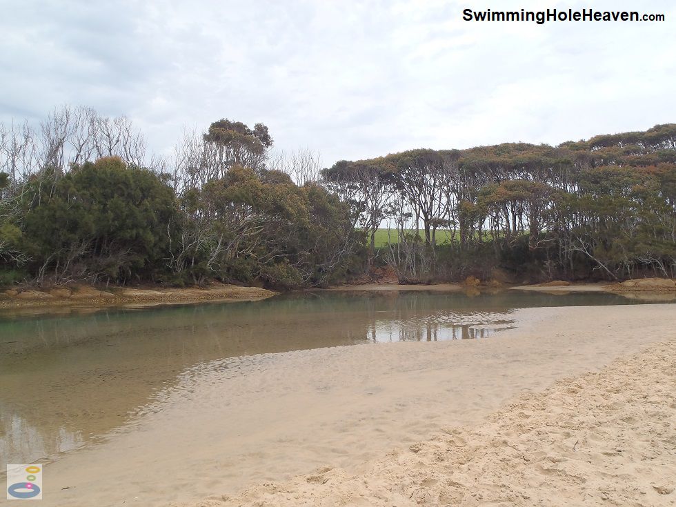
The outlet of Nangudga Lake, sometimes referred to as Handkerchief Lake, consists of a 300 metre long sandy channel that is fantastic for tube riding on the change of tides,
either side of high tide. The current is swift enough to push you along at moderate speed, and the water is mostly shallow enough to be able to stand up and walk out when
you are ready to hop out. On my visits there have usually been plenty of supervising adults walking in the water beside their young kids as they float up or down the channel.
 Above: The bend in the channel from which to launch your inflatable
(Order this image)
Either side of high tide it is deep enough for a swim in the middle of the channel. You can test yourself against the current in what is a natural swimming spa. After a dozen strokes I was just able to inch ahead a few metres at a time before drifting back with the current to catch my breath. I would then start to swim from the same spot again.
This is great if you want to have a long swim, but still want to keep an eye on your gear whilst in the water,
because like your gear, you never actually move! At low tide it is too shallow for a swim, but it is still suitable for shallow water play or sitting down in the water.
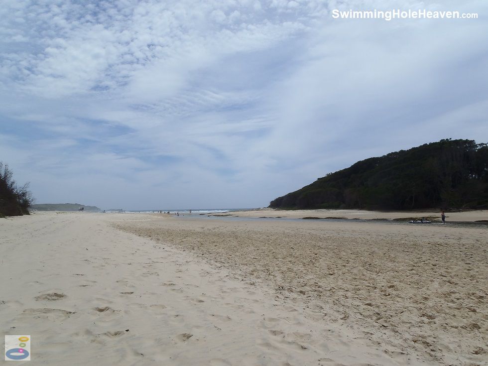
The mouth of the lake was very shallow during my visits, so it was easy enough to drift into the oncoming waves and simply stand up before reaching the ocean. It is always a good idea to check conditions at the exit of your tube ride before floating off into the water. Above: The long stretch of sand alongside the Nangudga lake outlet channel
(Order this image)
There are no picnic facilities here apart from a single picnic table, but there is a very small patch of grass next to the car park and heaps of soft sand to set yourself down on.
This spot also has the advantage that it can be sheltered from the wind by the trees on the bend of the channel, making it more attractive than
the beaches along the coast during blustery conditions. These trees can also provide a tiny bit of shade in the middle of the day.
Here is a video of my swim and tube ride at the lake on an outgoing tide. It was a few hours after high tide, and roughly half a metre below the high tide mark.
View Larger Map
 Above: The bend in the channel from which to launch your inflatable
(Order this image)
Either side of high tide it is deep enough for a swim in the middle of the channel. You can test yourself against the current in what is a natural swimming spa. After a dozen strokes I was just able to inch ahead a few metres at a time before drifting back with the current to catch my breath. I would then start to swim from the same spot again.
The mouth of the lake was very shallow during my visits, so it was easy enough to drift into the oncoming waves and simply stand up before reaching the ocean. It is always a good idea to check conditions at the exit of your tube ride before floating off into the water.
 Above: The long stretch of sand alongside the Nangudga lake outlet channel
(Order this image)
There are no picnic facilities here apart from a single picnic table, but there is a very small patch of grass next to the car park and heaps of soft sand to set yourself down on.
Here is a video of my swim and tube ride at the lake on an outgoing tide. It was a few hours after high tide, and roughly half a metre below the high tide mark.
Other Information Before You Go:
Location: Bertie Martin Drive (not named on Google Maps), off Princes Hwy, 4 km south of Narooma, 350 km (approx. 5 hour drive) south of the Sydney CBD or 220 km (approx. 3 hr drive)
south-east of Canberra.
Latitude:-36.253701 Longitude:150.142698
Getting there: From Narooma head along the Princes Hwy south for around 4 km. Head towards the beach along the dirt road immediately after the Island View Beach Resort but before you cross over Nangudga Lake. Veer right along this narrow dirt road and follow it 900 metres to the last car park along the road.
Facilities: Toilets, car park, picnic table, water tap.
Entrance fee: None
Water temperature: Mild to warm
Water clarity: Clear
Under foot: Sand with some rock and oysters on the opposite bank
Maximum water depth: 1-2 metres
Minimum swimming proficiency required: Beginners at low tide (under supervision), experienced at high tide and during swift changes in tide levels.
Prohibitions including whether you can bring your dog: No littering, no camping or overnight stays, no horses, no motorbikes, no vehicles on the beach, no golf, no fires, no dogs, no cutting of trees, no prawning
Sun shade: No shade on the water. Shade available back from the water under the trees that line the edge of the lake.
Opening times: Always open
Wheelchair access: Wheelchair accessible toilets. The area is flat, but there is a wide (approx 30 m) stretch of sand to cross before reaching the water.
Managing authority: Eurobodalla Shire Council
Nearby attractions: Corunna Lake Picnic Area, 2 km to the south.
Before you head out, make sure to read the
swimming safety information and check with the managing authority for any current change of conditions. Specific to this site, watch out for the oysters on the
rocks on the opposite bank, and be mindful that the current can be swift when the tides are changing.
Latitude:-36.253701 Longitude:150.142698
Getting there: From Narooma head along the Princes Hwy south for around 4 km. Head towards the beach along the dirt road immediately after the Island View Beach Resort but before you cross over Nangudga Lake. Veer right along this narrow dirt road and follow it 900 metres to the last car park along the road.
Facilities: Toilets, car park, picnic table, water tap.
Entrance fee: None
Water temperature: Mild to warm
Water clarity: Clear
Under foot: Sand with some rock and oysters on the opposite bank
Maximum water depth: 1-2 metres
Minimum swimming proficiency required: Beginners at low tide (under supervision), experienced at high tide and during swift changes in tide levels.
Prohibitions including whether you can bring your dog: No littering, no camping or overnight stays, no horses, no motorbikes, no vehicles on the beach, no golf, no fires, no dogs, no cutting of trees, no prawning
Sun shade: No shade on the water. Shade available back from the water under the trees that line the edge of the lake.
Opening times: Always open
Wheelchair access: Wheelchair accessible toilets. The area is flat, but there is a wide (approx 30 m) stretch of sand to cross before reaching the water.
Managing authority: Eurobodalla Shire Council
Nearby attractions: Corunna Lake Picnic Area, 2 km to the south.
Locality Map:
The marker indicates the approximate location of the car park beside the lake outlet channel. If the map is not zoomed in locally, as can sometimes occur when loading, simply click or tap on "View Larger Map" below.
View Larger Map
Comments:
If you would like to leave a comment about this swimming spot, please fill in the comment box below.
I am particularly interested in your experiences after visiting, and any changes in conditions, etc.
All fields are required if you would like your comments published on this website.
| ← Back stroke | Next swim → |
| NSW / ACT | NSW Sth Coast |
| Water Safety | Map |
| Links | Your Support |
| List of Lists | Suggest a Swim |
| Community, Media, Research | |
|
|
|
|
|
|
|
|
|
|
© Brad Neal 2024. All rights reserved. Swimming Hole Heaven is a registered trademark. Here is my
affiliate links and cookies policy and opportunities to provide support to Swimming Hole Heaven.
