| ← Back stroke | Next swim → |
Ovens River at Northern BeachesSwimming Hole Heaven in Victoria
| World Home Page |
| Australia Home |
| VIC Home |
| Regions of Victoria: |
| Melbourne |
| North East Victoria |
| Gippsland |
| Western Victoria |
| Other information: |
| Water Safety |
| Map |
| List of Lists |
| Order the Book |
| Your Support |
These are two steep, sandy beaches leading into deep water and a swift current, in a bushland reserve north of the Wangaratta town centre.
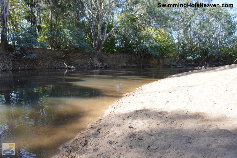
 Above: Platypus Beach at Northern Beaches, Wangaratta
(Order this image)
From the car park, it is a 200 metre walk along a wide gravel path through open scrubland to Platypus Beach. Facing north-west, this beach is in full sun for most of the day, with a steep descent down to the water.
The steep gradient continues into the water, which gets deep fairly quickly away from the bank. In the water I found it possible to swim against the current,
but there was a fallen tree in the middle of the river, mostly submerged, that I had to be careful not to scrape against or bump into. It was difficult to
see these snags in the slightly discoloured water, particularly when there were shadows on the surface. I found Playtpus Beach a nice spot for wading in the
river to cool down, and for swimming in one spot against the current, in between relaxing on the beach that overlooks the river. The beach is big enough to
accommodate several groups at any one time.
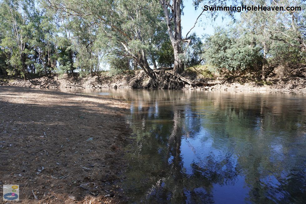
 Above: Kingfisher Beach at Northern Beaches, Wangaratta
(Order this image)
Kingfisher Beach was a further 600 metre walk into the woodland along a wide, well-defined gravel path. The sand was coarser here, but once on the beach, the entry into the water was not quite as steep.
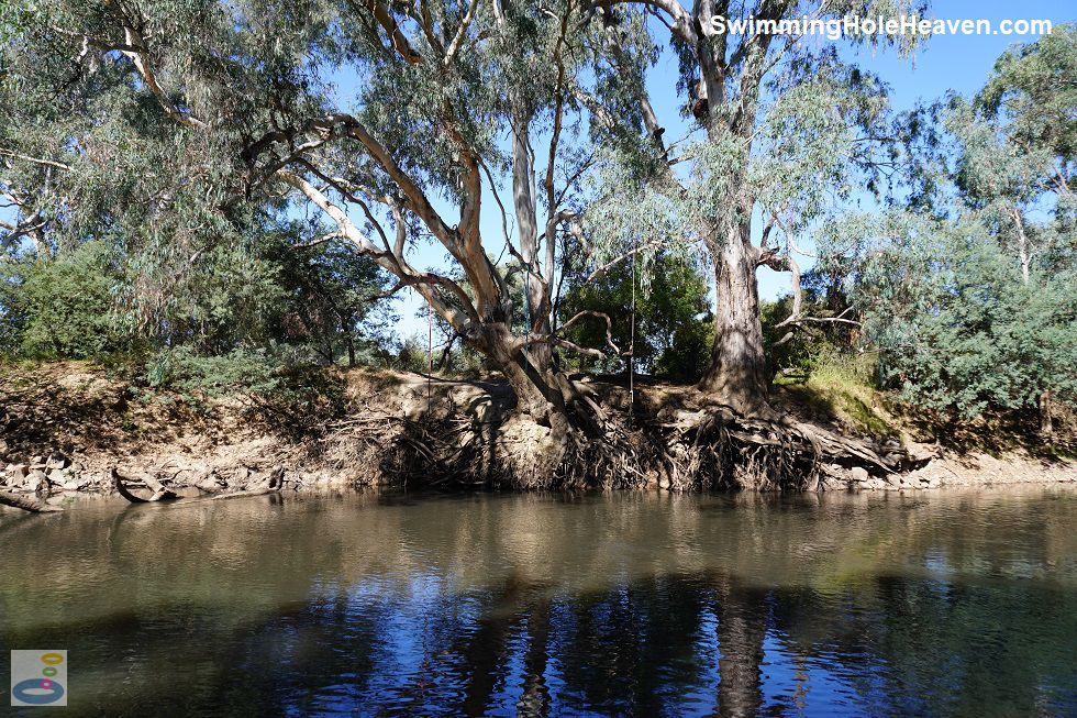
Kingfisher Beach boasted three makeshift rope swings hanging over a deep hole on the opposite bank. This stretch of the river also had a fallen tree at the
upstream end of the beach, that was a hazard for swimming. Kingfisher Beach was shadier and slightly smaller than Platypus Beach, and being a little more effort to reach, was quieter.
It also offered a gentler slope into the water.
 Above: The rope swings on the opposite bank at Kingfisher Beach
(Order this image)
Heading back from Kingfisher Beach, I continued along the circuit track through the bushland. The last part of the river loop track was not all that well-defined, so I would suggest you head back to the car park along the Treecreeper Track, which is also a bike path.
View Larger Map
 Above: Platypus Beach at Northern Beaches, Wangaratta
(Order this image)
From the car park, it is a 200 metre walk along a wide gravel path through open scrubland to Platypus Beach. Facing north-west, this beach is in full sun for most of the day, with a steep descent down to the water.
 Above: Kingfisher Beach at Northern Beaches, Wangaratta
(Order this image)
Kingfisher Beach was a further 600 metre walk into the woodland along a wide, well-defined gravel path. The sand was coarser here, but once on the beach, the entry into the water was not quite as steep.
 Above: The rope swings on the opposite bank at Kingfisher Beach
(Order this image)
Heading back from Kingfisher Beach, I continued along the circuit track through the bushland. The last part of the river loop track was not all that well-defined, so I would suggest you head back to the car park along the Treecreeper Track, which is also a bike path.
Other Information Before You Go:
Location: Northern Beaches, at the eastern end of College St, Wangaratta, 250 km (approx. 3 hr drive) north east of the Melbourne CBD
Latitude:-36.337446 Longitude:146.318760
Getting there: From Murphy St (C314) in town, head north along route C374 (Reid St, Rowan St, Green St, Evans St, then Edwards St). Head north again along Park Lane for 800 metres, then east into College St. The Northern Beaches car park is 350 metres further, at the end of College St. From the car park it is a 200 metre walk to Platypus Beach and a further 600 metre walk to Kingfisher Beach.
Facilities: Car park, rubbish bins, bags for dog droppings, bike path, a park bench (at Platypus Beach), information boards, a picnic table (overgrown, next to the car park).
Entrance fee: None
Water temperature: Mild
Water clarity: Cloudy
Under foot: Sand, gravel
Maximum water depth: Greater than 2 metres
Minimum swimming proficiency required: Experienced. The beaches are quite steep, there are submerged snags, and the current can be swift, making it difficult for inexperienced swimmers.
Prohibitions including whether you can bring your dog: On the paths from the car park to the beaches: no cars, no trail bikes. Dogs are permitted off-lead, as long as they are under effective control.
Sun shade: Shade available in the water. Limited shade on the beach, with more shade available at Kingfisher Beach than Platypus Beach. There was shade along most of the walking tracks.
Opening times: Always open
Wheelchair access: The gravel paths around Northern Beaches were wide and flat, and are likely to be wheelchair accessible, however access to Kingfisher Beach was steep, and access to the water at both beaches requires heading across loose sand.
Managing authority: Rural City of Wangaratta
Nearby attractions: Take the kids to Mitchell Avenue Splash Park in Wangaratta, a free splash park 6 km to the south.
Before you head out, make sure to read the
swimming safety information and check with the managing authority for any current change of conditions.
Latitude:-36.337446 Longitude:146.318760
Getting there: From Murphy St (C314) in town, head north along route C374 (Reid St, Rowan St, Green St, Evans St, then Edwards St). Head north again along Park Lane for 800 metres, then east into College St. The Northern Beaches car park is 350 metres further, at the end of College St. From the car park it is a 200 metre walk to Platypus Beach and a further 600 metre walk to Kingfisher Beach.
Facilities: Car park, rubbish bins, bags for dog droppings, bike path, a park bench (at Platypus Beach), information boards, a picnic table (overgrown, next to the car park).
Entrance fee: None
Water temperature: Mild
Water clarity: Cloudy
Under foot: Sand, gravel
Maximum water depth: Greater than 2 metres
Minimum swimming proficiency required: Experienced. The beaches are quite steep, there are submerged snags, and the current can be swift, making it difficult for inexperienced swimmers.
Prohibitions including whether you can bring your dog: On the paths from the car park to the beaches: no cars, no trail bikes. Dogs are permitted off-lead, as long as they are under effective control.
Sun shade: Shade available in the water. Limited shade on the beach, with more shade available at Kingfisher Beach than Platypus Beach. There was shade along most of the walking tracks.
Opening times: Always open
Wheelchair access: The gravel paths around Northern Beaches were wide and flat, and are likely to be wheelchair accessible, however access to Kingfisher Beach was steep, and access to the water at both beaches requires heading across loose sand.
Managing authority: Rural City of Wangaratta
Nearby attractions: Take the kids to Mitchell Avenue Splash Park in Wangaratta, a free splash park 6 km to the south.
Locality Map:
The marker indicates the approximate location of the car park at Northern Beaches. If the map is not zoomed in locally, as can occur with some browsers, simply click or tap on "View Larger Map" below.
View Larger Map
Comments:
If you would like to leave a comment about this swimming hole, please fill in the comment box below. I'm particularly interested in your
experiences after visiting, and any changes in swimming conditions. All fields are required if you would like your comments published on this website.
| ← Back stroke | Next swim → |
| Victoria | Nth East VIC |
| Water Safety | Map |
| List of Lists | Suggest a Swim |
| Links | Your Support |
| Media | Order the Book |
|
|
|
|
|
|
|
|
|
|
© Brad Neal 2024. All rights reserved. Swimming Hole Heaven is a registered trademark. Here are my
affiliate links and cookies policy and opportunities to provide support to Swimming Hole Heaven.