| ← Back stroke | Next swim → |
Tarago River at Picnic PointSwimming Hole Heaven in Victoria
| World Home Page |
| Australia Home |
| VIC Home |
| Regions of Victoria: |
| Melbourne |
| North East Victoria |
| Gippsland |
| Western Victoria |
| Other information: |
| Water Safety |
| Map |
| List of Lists |
| Order the Book |
| Your Support |
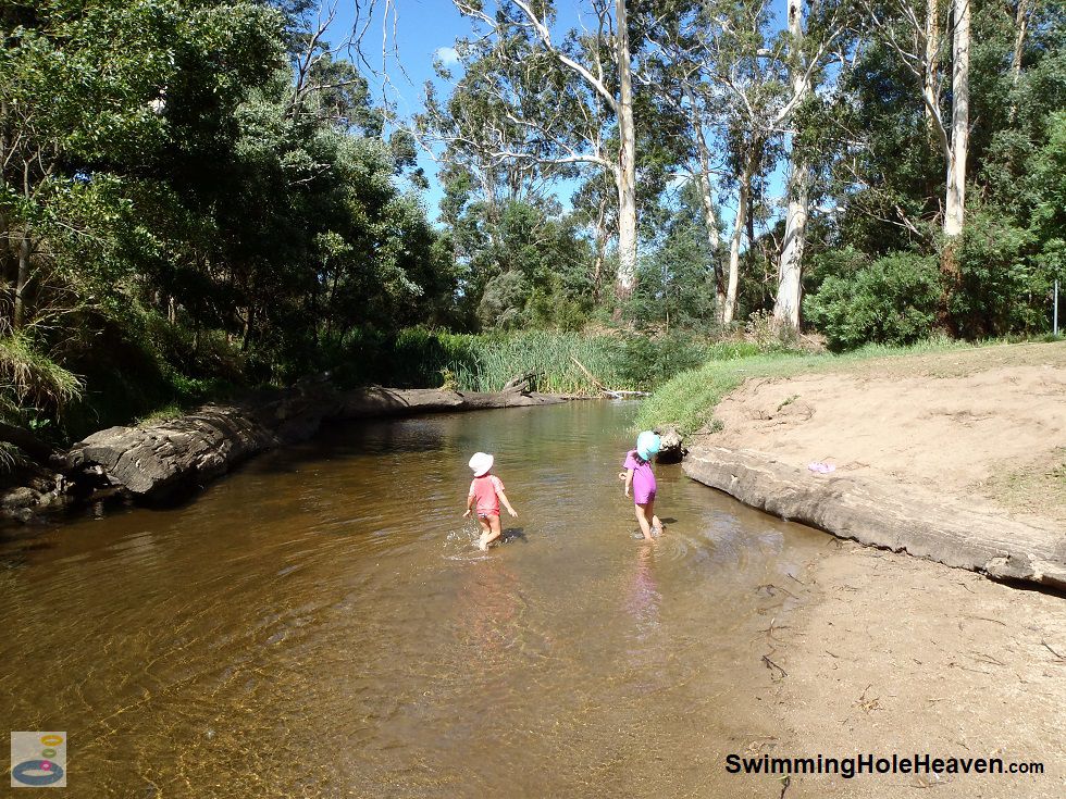
Picnic Point in Longwarry North has a small grassy knoll with a bank that leads down to the Tarago River. The river has a shallow,
sandy beach, with a 20-30 metre stretch of clear, shallow water upstream that you can wade into, splash around in or sit yourself down in.
The deepest section of the river upstream of the beach is on the far side, which measured around half a metre deep at the time of my
visit in late summer. The river is flanked by fallen tree trunks on either side, which adults can sit on and dangle their feet in the water.
 Above: Walking in the shallows of the Tarago River at Picnic Point
(Order this image)
There were a few points of note in the water. The section of river directly in front of the lawn had a sand bottom throughout, which was comfortable on your feet, but there was a very light dusting of silt in parts on top of the sand, that stirred up when you walked in the water.
It had rained the day before I visited, and my nose picked up a slight pong to the water, similar to what you would find
in the mid-Yarra around Warrandyte.
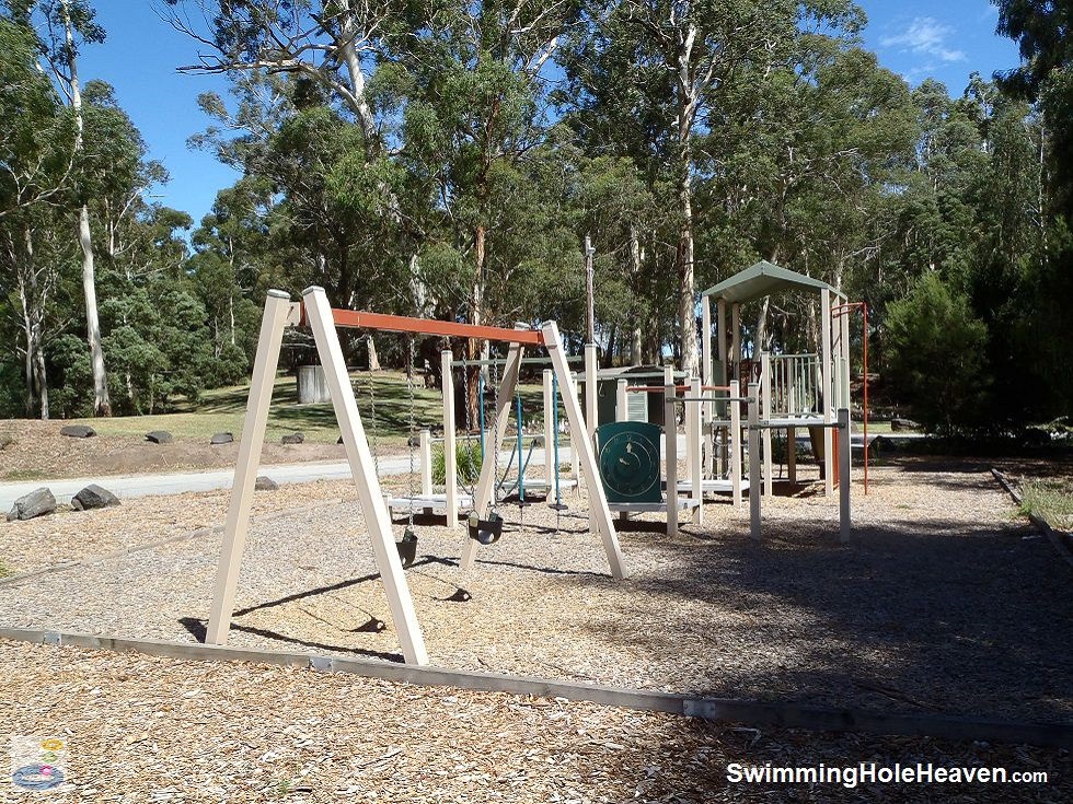
 Above: The kids playground at Picnic Point
(Order this image)
The agricultural areas along the river upstream of Picnic Point are likely to contaminate the water with animal poo after rainfall, so I would avoid getting in the water here in the first 24-48 hours after rainfall. Similarly, I suggest you don't swim here if you have any open cuts on your body. There was a deep hole in the river immediately downstream of the beach, so steer your kids towards the area upstream of the beach, away from this hole.
The spot is also popular with adults, and on my visit I saw a young couple in bathers roll up and wade into the water as we were leaving. If the beach immediately in front of the lawn area is crowded, there is also a smaller beach on the bend about 80 metres downstream.
That beach is on the opposite side of the river and further away from the car park, so is better suited to adults than children.
As the name suggests, this spot is very nice for a picnic. There are towering white gum trees, several lawns to spread out a picnic blanket and a couple of barbecue hot plates. There is also a little playground with a range of equipment primarily targetted at younger children, such as a small slide, swings, and various small climbing structures.
View Larger Map
 Above: Walking in the shallows of the Tarago River at Picnic Point
(Order this image)
There were a few points of note in the water. The section of river directly in front of the lawn had a sand bottom throughout, which was comfortable on your feet, but there was a very light dusting of silt in parts on top of the sand, that stirred up when you walked in the water.
 Above: The kids playground at Picnic Point
(Order this image)
The agricultural areas along the river upstream of Picnic Point are likely to contaminate the water with animal poo after rainfall, so I would avoid getting in the water here in the first 24-48 hours after rainfall. Similarly, I suggest you don't swim here if you have any open cuts on your body. There was a deep hole in the river immediately downstream of the beach, so steer your kids towards the area upstream of the beach, away from this hole.
The spot is also popular with adults, and on my visit I saw a young couple in bathers roll up and wade into the water as we were leaving. If the beach immediately in front of the lawn area is crowded, there is also a smaller beach on the bend about 80 metres downstream.
As the name suggests, this spot is very nice for a picnic. There are towering white gum trees, several lawns to spread out a picnic blanket and a couple of barbecue hot plates. There is also a little playground with a range of equipment primarily targetted at younger children, such as a small slide, swings, and various small climbing structures.
Other Information Before You Go:
Location: Princes Way, Longwarry North, 90 km (approx. 1 hr 15 min drive) south-east of the Melbourne CBD.
Latitude:-38.083376 Longitude:145.812805
Getting there: From Melbourne head along the Monash Fwy (M1) to the Sand Road exit at Longwarry North. At the end of Sand Road head east along Princes Way for 3 km until you see the Picnic Point sign. Parking is available in the park.
Facilities: Toilet, picnic tables (sheltered), barbecues (sheltered), playground, rubbish bins, lawn areas, information boards.
Entrance fee: None
Water temperature: Mild
Water clarity: Clear
Under foot: Sand and silt
Maximum water depth: 1-2 metres
Prohibitions including whether you can bring your dog: No camping, no staying in caravans, no dumping of rubbish, no fires in the picnic shelter. Dogs permitted.
Sun shade: Shade available out of the water. Shade available in the water only in the early morning and late afternoon.
Opening times: Always open
Wheelchair access: There is no formal wheelchair access, but the toilet appears to have room for a wheelchair and the picnic area is fairly flat, except for the short slope down to the river.
Managing authority: Baw Baw Shire Council
Nearby attractions: Robin Hood Streamside Reserve, which is a couple of kilometres further down the road towards Drouin, but less inviting for swimming.
Before you head out, make sure to read the
swimming safety information and check with the managing authority for any current change of conditions.
Latitude:-38.083376 Longitude:145.812805
Getting there: From Melbourne head along the Monash Fwy (M1) to the Sand Road exit at Longwarry North. At the end of Sand Road head east along Princes Way for 3 km until you see the Picnic Point sign. Parking is available in the park.
Facilities: Toilet, picnic tables (sheltered), barbecues (sheltered), playground, rubbish bins, lawn areas, information boards.
Entrance fee: None
Water temperature: Mild
Water clarity: Clear
Under foot: Sand and silt
Maximum water depth: 1-2 metres
Prohibitions including whether you can bring your dog: No camping, no staying in caravans, no dumping of rubbish, no fires in the picnic shelter. Dogs permitted.
Sun shade: Shade available out of the water. Shade available in the water only in the early morning and late afternoon.
Opening times: Always open
Wheelchair access: There is no formal wheelchair access, but the toilet appears to have room for a wheelchair and the picnic area is fairly flat, except for the short slope down to the river.
Managing authority: Baw Baw Shire Council
Nearby attractions: Robin Hood Streamside Reserve, which is a couple of kilometres further down the road towards Drouin, but less inviting for swimming.
Locality Map:
The marker indicates the approximate location of the car park at Picnic Point. If the map is not zoomed in locally, as can occur with some browsers, simply click or tap on "View Larger Map" below.
View Larger Map
Comments:
If you would like to leave a comment about this swimming spot, please fill in the comment box below. I'm particularly interested in your
experiences after visiting, and any changes in swimming conditions. All fields are required if you would like your comments published on this website.
| ← Back stroke | Next swim → |
| Victoria | Gippsland |
| Water Safety | Map |
| List of Lists | Suggest a Swim |
| Links | Your Support |
| Media | Order the Book |
|
|
|
|
|
|
|
|
|
|
© Brad Neal 2024. All rights reserved. Swimming Hole Heaven is a registered trademark. Here are my
affiliate links and cookies policy and opportunities to provide support to Swimming Hole Heaven.